digitalcourage.social is one of the many independent Mastodon servers you can use to participate in the fediverse.
Diese Instanz wird betrieben von Digitalcourage e.V. für die Allgemeinheit. Damit wir das nachhaltig tun können, erheben wir einen jährlichen Vorausbeitrag von 1€/Monat per SEPA-Lastschrifteinzug.

Server stats:

816
active users

#rockcarvings

0 posts0 participants0 posts today

World heritage: Rock carvings in Tanum, Sweden.

Have you ever heard about that before?

"...large number of rock carvings from the Bronze Age (1700-500 BC) found in the area. The entire region of Bohuslän is rich in rock carvings, with the majority located in the northern part. Tanum has the highest concentration of rock carvings and offers an unusually diverse range of imagery. ..."

#RockCarvings
#Tanum
#Sweden
#BronzeAge

tanumworldheritage.se/?lang=en

Världsarvet Tanums hällristningarTanum rock carvings - Världsarvet Tanums hällristningarWorld Heritage site in Sweden with rock carvings from the Bronze Age. Read about the area's attractions and how it is managed.

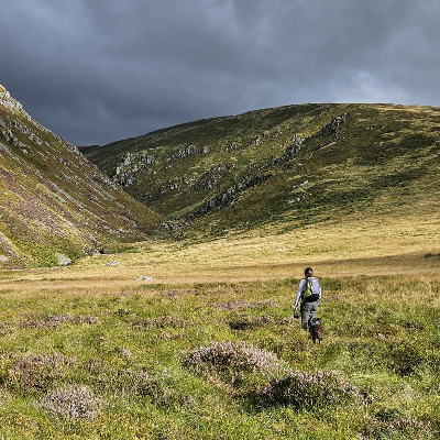
The other day I was up in a favourite local spot, Goats Crag. These carvings are a little way off the main path and hard to find unless you know where they are. Believed to represent goats, although whether that's because of the name or the name was given because of the carvings, I'm not sure. They could really be any kind of quadruped, but I'm happy to accept the folklore!

Their age is unknown, and they probably aren't truly ancient (I've heard guesses from Iron Age to Roman to Medieval; if they were really prehistoric, they'd be incredibly rare in Britain), but early Bronze Age burials have been found close by, and one of the largest occurrences of cup and ring marks is also not far away, as well as an Iron Age fort.

#Northumberland #folklore #history #prehistory #archaeology #RockCarvings @folklore

Continued thread

To add context for anyone interested in the layout of the #Prehistoric site, here is some lidar data, which makes it much clearer than Google Maps can, as it reveals what's hidden under the tree cover. I'd scrambled through those ditches a hundred times and never realised how they formed a picture with the landscape until I saw maps showing this.

My guess would be that they post-date the #CupAndRingMarks (second pic) outside the embankments, but I'm no expert.