ALERTE nouvel article : Réseau réunionnais : Retour sur l’Atelier Découverte du 31 août 2025
https://gaulix.fr/reseau-reunionnais-retour-sur-latelier-decouverte-du-31-aout-2025/
ALERTE nouvel article : Réseau réunionnais : Retour sur l’Atelier Découverte du 31 août 2025
https://gaulix.fr/reseau-reunionnais-retour-sur-latelier-decouverte-du-31-aout-2025/
Ich habe als Programmierübung aus der "Liste der #Ladesäulen" der Bundesnetzagentur, alle DC-Ladesäulen extrahiert, die Zahlung mittels #Debitkarte oder #Kreditkarte am #Leseterminal akzeptieren.
Ich habe das Ergebnis in eine #uMap eingegeben mit den Ebenen
<100kW, 100-200kW, >200kW.
Vielleicht ist das für jemanden nützlich:
Hintergrund:
Man hat vielleicht nicht immer eine #Ladekarte oder #Smartphone dabei oder möchte nicht mit Smartphone seine Kartendaten auf windigen Websites eingeben. Oder man hat einen Mietwagen...
Außerdem hasse ich "Schattenwährungen", Abomodelle, Prämienprogramme und Data-Spreading...
Alle ab 01.07.2024 ERRICHTETEN Ladesäulen müssen diese Möglichkeit der Bezahlung bieten.
Die gängigen Apps bieten hier keine Filtermöglichkeit.
#ElektroAuto
Ciao a tuttə,
bevenutə sull'account Mastodon delle amiche e degli amici del FuoriPertini Cornaggia.
Questo account accompagnerà e sosterrà le attività di questa sede decentrata della biblioteca Il Pertini di Cinisello Balsamo (https://www.ilpertini.com/) e si occuperà naturalmente anche di libri e letture.
Ma prima di tutto, dove si trova il FuoriPertini Cornaggia?
Si trova in via Cornaggia 37, presso la sede del circolo AMIS “Emilio Lussu” (http://www.circoloamis.it/index.html ), proprio di fronte all’hotel Holiday Inn, è raggiungibile dal viale Brianza per chi viene da Milano e dalla via Matteotti e dal successivo sottopasso Cornaggia per chi viene da Cinisello o da Monza.
La mappa qui sotto ci può aiutare a non perderci e a raggiungere il
FuoriPertini. (https://umap.openstreetmap.fr/it/map/fuoripertini-cinisello_1280123#18/45.55247/9.24009)
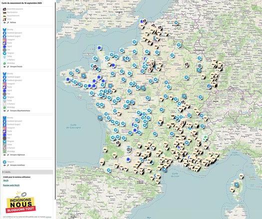
> Une carte regroupant les liens vers les différentes initiatives liées au 10 septembre est hébergée sur #uMap
>
> Sur la seule journée d’hier, elle a été consultée plus de 136 000 fois soit environ 15% du trafic global sur uMap !
>
> @cquest sur le forum https://forum.openstreetmap.fr/t/umap-et-le-10-septembre-2025/37386
Scopro oggi questa mappa di Rai Cultura sui Luoghi del patrimonio culturale italiano, che ne pensate? https://www.raicultura.it/webdoc/luoghi-del-patrimonio-culturale-italiano/index.html #OpenStreetMap #uMap
[#veille] Cartographie des crimes de guerre mentionnés dans les dossiers d’enquête de police judiciaire conservés aux Archives nationales
Billet méthodologique sur le carnet de recherche des #Archivesnationales : https://labarchiv.hypotheses.org/4345
Cartographie sur #uMap : http://u.osmfr.org/m/1231168/
#histoire #histodons #2GM #WW2 #crimesdeguerre #archives #cartographie #20esiecle #France #worldwar2 @archivistodon
Atelier State of the map 2025 : Grist  uMap - Tutoriel
@JDersvenheisst @marove Das wäre mit #umap wohl auch schnell gemacht  ️
️
@m_b war so freundlich aufzuschreiben, wie wir mit der offenen Software #UMap von #OSM und #360Grad-Fotos mit Kindern und Jugendlichen einen digitalen Plan erstellen, hier als #Konfi-Camp-Map mit den schönsten Plätzen. Veröffentlicht als #OER unter #CCBY, also bitte unbedingt nachmachen!
@OffenerKanal_MQ @netzwerkmk @EKM_online #KonfiCamp der @EkD @bpb @bildungsachsenanhalt @oerinfo
#OpenStreetMap #FLOSS #offeneSoftware #offeneGesellschaft
https://ev-akademie-wittenberg.de/diskurs/mitmachmap-die-anleitung/
[Erledigt] Moin #OSM|-Community! Wir wären für einen Tipp zu #uMap dankbar: Wie würde man eine dort sehr grob mit wenigen Wegpunkten gezogene Route (siehe Beispielbild) möglichst schnell so verfeinern, dass sie Straßen und Wegen folgt, so dass die Strecken- und Steigungsangaben realistisch werden?
Also im Prinzip das, was Komoot macht, wenn man so ein rohes GPX importiert und sagt, es solle zur Neuplanung vorhandene Wege nehmen – aber aus Gründen eben gern ohne Komoot :-) Gibt es da entsprechende Dienste im OSM-Universum? Danke!
In OpenStreetMap news - uMap now has a feature to print the map.
Finally, let's say you want to plan your next bike trip with #uMap from Parc Jean-Drapeau to a popular view point of Mont-Royal stopping by Parc Lafontaine and Lac aux Castors, use the new routing icon and there we go. The icing on the cake  , is to ask for elevations and display the elevation graph at the end (see previous toot) to know when your legs will suffer the most!
Another example, this time to setup a route from a GPX file with elevation graph. The GPX file is dropped on an empty #uMap map and the the large popup with a Route template is applied to the imported line (see how you can track the current elevation hovering the graph  ):
):
An example of how to compute an isochrone with #uMap from a given point (right-click from anywhere on a map), here with a 20 min range by bike from an island for a better demonstration:
#uMap 3.3.0 is out 
A huge release dedicated to… summer time 
Enjoy your hikes, bikes and so much more! 
https://docs.umap-project.org/en/master/changelog/#330-2025-08-14
Thanks to OpenRouteService for their directions, isochrones and elevations API! https://openrouteservice.org/
Check out examples from this thread 
Meine liebsten OpenStreetMap-Angebote
* #Mapy - fast wie Google Maps (mit Kommentare, Routen, Umgebung) https://mapy.com/de/zakladni?source=osm&id=11945282&x=9.9698595&y=53.4611790&z=19
* #uMap - eigene interaktive Karten: super https://umap.openstreetmap.de
* #F4map - 3D is teinfach cool https://demo.f4map.com/#lat=53.5411920&lon=9.9856098&zoom=18
* #MapComplete (POIs) https://mapcomplete.org
* POI-Karte (Filter links!) https://www.flosm.org/de/POI-Karte.html?lat=53.4624300&lon=9.97572439&r=1352.9117
* #Wanderer (Spazieren) https://trails.magdeburg.jetzt/map?lat=53.550341&lon=10.000654&tl_lat=53.796000230890115&tl_lon=10.604031966978994&br_lat=53.28209555774936&br_lon=9.413455372160684
* #OpenRailwayMap https://www.openrailwaymap.org/
#OSM #OpenStreetMap #GoogleMaps -Alternativen
Die #Radsternfahrt #uMap ist für die Veröffentlichung vorbereitet und sie füllt sich stetig mit weiteren Zubringern.
Von wo würdet ihr gerne einsteigen? Meldet gerne euren Zubringer – je weiter weg, desto besser!
https://umap.openstreetmap.de/de/map/radsternfahrt-stuttgart-2025_81939
@ADFC_BW @adfc_stuttgart @criticalmassstuttgart @mastobikes_stuttgart @mastobikes_de @fedibikes_de @zweirat0711@a.gup.pe @radelninbb @radritterin
@criticalmassgd @criticalmass @adfc_karlsruhe @adfc_ffm @adfc_ulm @ADFC_Muenchen @ADFC_Offenburg